Sunday late evening thunderstorms not only brought a few pockets of wind damage but also dropped enough rain to ensure fog and low-altitude, gray clouds filled in for many New England communities Monday morning.
Enough dry air aloft will mix through the clouds by mid to late morning, allowing sunshine to not only break out but take over by afternoon as humidity levels gradually fall, so Monday evening will be noticeably less humid than the morning was.
Download our free mobile app for iOS or Android to get the latest breaking news and in-depth coverage of COVID-19.
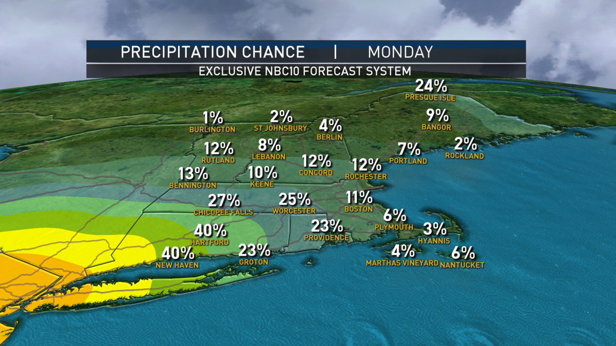
With less humid air easing across New England and high temperatures kept in check at just above 80 degrees inland and 70s along the coast, showers will be limited to Connecticut and southwest Massachusetts Monday afternoon, but during Monday evening and overnight, those will migrate northeast across interior Massachusetts while likely weakening to only scattered sprinkles by Tuesday morning.
Tuesday brings variable clouds, with high temperatures in the 70s for most, but deeper warmth and humidity won’t be far away and an increasing southwest wind Wednesday will drag that air back into New England, boosting temperatures into the 80s as humidity rises.
A passing disturbance aloft Wednesday evening will raise the chance for scattered showers and thunder late Wednesday, but also open the door for even warmer to downright hot air to arrive Thursday and Friday, with high temperatures around 90 degrees and plenty of humidity. Although a thunderstorm certainly is possible both days, no strong disturbance appears to be a focus for widespread storm development at this point.
Meanwhile, the weather world will turn its attention to a developing storm center off the southeast United States coast late this week. Currently just moving northeast over the Panhandle of Florida, this storm center will re-emerge over water off Georgia and the Carolinas by midweek, and the Atlantic water and Gulf Stream is warm this time of the year, so this blossom of tropical moisture has at least some potential to consolidate into a numbered or named tropical system.
Either way, the chance for organized showers and thunder rises Saturday in New England as this system nudges northward, though it remains to be seen if it stays intact as it makes that move – if so, bouts of heavy rain, thunder and wind would be possible Saturday but it’s too early to say with certainty. Summer air and a chance of scattered thunder continues into at least the start of next week in our exclusive First Alert 10-day forecast.
"again" - Google News
July 06, 2020 at 09:01PM
https://ift.tt/2ZEDSjy
Heat Builds Again This Week, Chance for More Storms - NBC10 Boston
"again" - Google News
https://ift.tt/2YsuQr6
https://ift.tt/2KUD1V2
Bagikan Berita Ini


0 Response to "Heat Builds Again This Week, Chance for More Storms - NBC10 Boston"
Post a Comment